
Nevada's scenic drives offer everything from alpine lakes to alien-themed gas stations, though you'll want to remember one crucial detail: the next gas station might be 160 miles away. Whether you're chasing Instagram-worthy red rocks or seeking complete solitude on America's loneliest highway, these 34 designated scenic byways deliver experiences ranging from world-famous to "wait, people actually live here?"
Planning your Nevada road trip (or how not to become a cautionary tale)
Let's start with the most important advice you'll get in this entire article: fill up your gas tank whenever it hits half full. I know that sounds paranoid, but Nevada's fuel gaps can stretch up to 160 miles between stations. That's not a typo. That's the actual distance between Fallon and Austin on Highway 50, where running out of gas means waiting hours for help… if you have cell service to call for it.
Essential resources that might save your bacon
The Nevada 511 app should be your new best friend. It shows real-time road conditions, traffic cameras, and weather alerts. More importantly, screenshot everything before you leave civilization because your phone will become an expensive paperweight on most scenic routes. GPS also tends to fail spectacularly in canyons, so yes, you actually need those old-school paper maps your dad insists on keeping in the glove compartment.
Pack like you're preparing for the apocalypse, because in some parts of Nevada, you basically are. The desert demands respect: one gallon of water per person per day, basic tools, and ideally a satellite communicator. Emergency services might be 100+ miles away, and that's assuming someone knows you need help.
When to visit (spoiler: not in summer unless you enjoy melting)
Timing your Nevada road trip requires understanding that this state has seven different climate zones. Yes, seven. Here's the breakdown that'll keep you from either freezing or frying:
Southern Nevada shines from October through April when temperatures drop from "surface of Mercury" to "actually pleasant." Skip May through September unless you enjoy 110°F heat and watching your dashboard literally crack.
Northern Nevada and the Tahoe region stay accessible year-round, but winter means chain requirements on mountain passes. If you don't know how to install chains, practice in your driveway first… trust me on this one.
Central and Eastern Nevada perform best in April-May and September-October. Winter closes many high-elevation attractions completely. Wheeler Peak Scenic Drive? Closed October through May. Lamoille Canyon? Same deal. Berlin-Ichthyosaur? You get the idea.
Southern Nevada: Where red rocks meet roadside entertainment
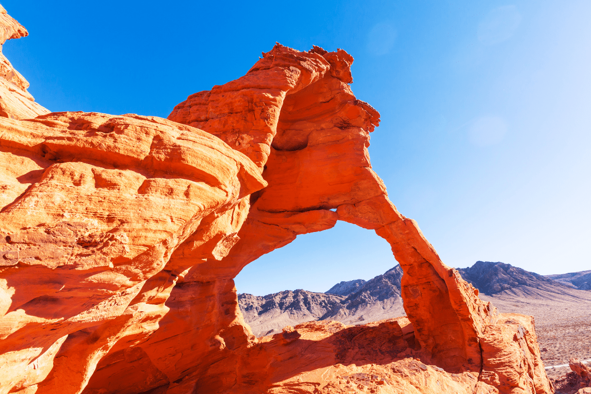
The Valley of Fire Highway might be Nevada's most photogenic 10.7 miles, located just 50 miles from Las Vegas. Add the 5.7-mile White Domes Road and 3-mile Scenic Loop, and you've got enough ancient geology to fill a thousand Instagram feeds.
Valley of Fire: Nature's own theme park
This state park sees over 250,000 visitors annually, all coming to gawk at 150-million-year-old Aztec sandstone formations. Fun fact: Star Trek Generations filmed alien planet scenes here, probably because it already looks like Mars decided to vacation in Nevada.
Budget 2-3 hours minimum, though you'll likely stay longer once you see Fire Wave Trail's undulating red rocks. The $15 entrance fee for non-residents feels like highway robbery until you realize Vegas shows charge five times that for fake volcanoes. Pro tip: Elephant Rock near the east entrance offers the last reliable cell coverage, so send your "still alive" texts here.
Avoid visiting between May 15 and September 30 unless you enjoy hiking when it's over 100°F and the trails literally close for human safety. Also, there's absolutely no fuel in the park. None. Zero. Fill up in Las Vegas or resign yourself to an expensive tow truck ride.
Red Rock Canyon: Now with reservation requirements
Red Rock Canyon's 13-mile scenic loop used to be Vegas's worst-kept secret. Now it requires timed reservations between October 1 and May 31, managing crowds that exceed 3 million annual visitors. The reservation system on Recreation.gov opens 30 days in advance, and slots disappear faster than free buffet coupons on the Strip.
The one-way paved road climbs from desert floor to over 4,000 feet at High Point Overlook, showcasing the Keystone Thrust geological fault. You'll drive at an enforced 25 mph, which initially feels painfully slow until you realize it gives you time to spot bighorn sheep and avoid cyclists who apparently think they're in the Tour de France.
Must-see stops along the loop:
- Calico Hills for sunset photography
- Ice Box Canyon for actual shade
- Pine Creek Canyon for moderate hiking
- High Point Overlook for valley views
- Willow Springs for prehistoric petroglyphs
The $20 vehicle entrance fee covers seven days, though cell service remains virtually nonexistent throughout. Last chance for fuel sits at Charleston Boulevard and Desert Foothills Drive. After that, you're committed.
Mount Charleston: Las Vegas's backyard alpine escape
When Vegas locals say they're "going to the mountain," they mean the Mount Charleston Scenic Byway. This 40-mile loop combines three roads (SR-157, SR-156, and SR-158) while climbing from 2,500 feet in the valley to over 8,000 feet through seven climate zones.
The temperature drops 20-30°F cooler than Vegas, making summer actually bearable. Mount Charleston Lodge at 7,717 feet serves surprisingly good food with views of Nevada's fifth-tallest peak. In winter, Lee Canyon operates as Nevada's closest ski resort to a major city, though "ski resort" might be generous for what's essentially three lifts and a determination to make snow in the desert work.
Critical warning: No fuel exists on the mountain. None. Plan for a 100+ mile round trip from Vegas. Winter occasionally requires chains above 7,000 feet, turning the scenic drive into an impromptu driving skills test.
Northern Nevada: Tahoe views and mining ghost towns
The Tahoe region delivers what Lonely Planet calls "the most beautiful drive in America," though they apparently haven't driven every road in America to verify this claim.
Lake Tahoe loop: 72 miles of "are we still in Nevada?"
The complete Lake Tahoe loop covers 72 miles combining US-50, NV-28, and various local roads. The crown jewel is the East Shore Drive (NV-28), a 28-mile National Scenic Byway from Crystal Bay to Spooner Lake that makes you question whether you've accidentally driven into a tourism commercial.
Critical stops that'll have you pulling over every five minutes:
- Sand Harbor State Park ($10 parking)
- Memorial Point Scenic Overlook
- Cave Rock (sacred Washoe site)
- Emerald Bay's Fannette Island
- D.L. Bliss State Park
Winter driving requires either 4WD/AWD with snow tires OR chains on all vehicles during restrictions. Check nvroads.com or call 511 before heading up, unless you enjoy learning to install chains during a blizzard while other drivers honk at you.
Fuel strategically at these locations: South Lake Tahoe's Safeway, Tahoe City's Chevron at highways 89/28, or Incline Village's multiple stations. The east and west shores offer limited options, and "limited" means "hope you like walking."
Cell coverage varies dramatically by carrier. Verizon provides 95% coverage in populated areas, while AT&T and T-Mobile users should prepare for dead zones between towns. Download offline maps unless you enjoy playing "guess which turn leads back to civilization."
Mount Rose Highway: Nevada's highest year-round pass
Mount Rose Highway (NV-431) climbs from Reno's 4,500 feet to Mount Rose Summit at 8,911 feet, making it Nevada's highest year-round Sierra pass. The 24.3-mile route takes 40 minutes if you drive straight through, but that's like ordering a sandwich at a five-star restaurant.
The summit receives 400 inches of annual snow, which sounds made up until you're driving through it. Multiple viewpoints near Incline Village showcase Lake Tahoe, while the Mount Rose Ski Area Overlook reveals Washoe Valley 4,000 feet below. It's the kind of view that makes you pull over and contemplate life choices, like why you live somewhere without mountains.
Chains frequently control traffic from October through April, with avalanche operations causing delays that'll test your podcast library. No services exist at the summit, so fuel up in Reno or Incline Village unless you fancy a very cold, very long walk down.
Pyramid Lake: Ancient waters and permit requirements
The Pyramid Lake Scenic Byway forms a Y-shaped route using three highways to showcase Nevada's desert sea. Mullen Pass Overlook reveals the entire ancient Lake Lahontan remnant with its 400-foot Pyramid Rock, looking like nature's unsuccessful attempt at recreating Egyptian architecture.
Here's what makes this drive special and slightly complicated:
- Permits required from Pyramid Lake Museum
- Only fuel at Sutcliffe Marina after Sparks
- 80+ mile round trip minimum
- Spring brings Lahontan cutthroat spawning
- Marble Bluff Fish Hatchery viewable spawning
The Pyramid Lake Paiute Tribe requires permits for all activities including photography, because nothing says "scenic drive" like bureaucracy. Still, the lake's otherworldly blue against desert mountains makes the permit process worthwhile.
Central and Eastern Nevada: Welcome to the middle of nowhere
If Southern Nevada is the showboat and Northern Nevada is the outdoorsy friend, Central and Eastern Nevada is that uncle who lives off-grid and might be a genius or completely insane.
Highway 50: Earning its "loneliest" reputation
Highway 50 spans 409 miles across Nevada, with the 287-mile section from Fernley to the Utah border earning its "Loneliest Road in America" title. This isn't marketing hyperbole. You might drive hours without seeing another vehicle, cell coverage disappears entirely between towns, and emergency services sit 100+ miles away.
The route crosses 17 mountain passes including Connors Pass at 7,729 feet. Between Fallon and Austin lies the longest fuel gap at 160 miles. Let that sink in. That's like driving from Los Angeles to San Diego with no gas stations. Middlegate Station operates "seasonally," which in Nevada means "when they feel like it."
Essential Highway 50 survival stops:
- Austin's International Hotel
- Stokes Castle overlook
- Eureka's Opera House
- Spencer Hot Springs (110-130°F pools)
- Sand Mountain Recreation Area
Allow 6-7 hours for straight-through driving, but that defeats the purpose. Plan 2-3 days to explore properly, because rushing through the Loneliest Road is like speed-reading poetry… technically possible but missing the point entirely.
Great Basin National Park: Wheeler Peak's exclusive drive
Wheeler Peak Scenic Drive climbs 4,000 feet in just 12 miles, starting at Lehman Caves Visitor Center (6,800 feet) and ending at Wheeler Peak Campground (10,000+ feet). The road discriminates against large vehicles: no trailers or RVs over 24 feet past mile 3. Sorry, land yacht owners.
The narrow, winding road enforces 35 mph with no passing zones, though you'll be too busy avoiding edges to speed anyway. Stop at Mather Overlook (mile 8) for 9,000-foot views and Wheeler Peak Overlook (mile 10) for glacial cirque vistas that'll make your Instagram followers think you've left Nevada entirely.
Upper sections close October through May for snow, because even Nevada has limits. No cell service exists, and the nearest fuel sits 67 miles away in Ely. Pack snacks, water, and patience for tourists who stop in the middle of the road for photos.
Extraterrestrial Highway: More cows than aliens
Route 375, officially designated the Extraterrestrial Highway, runs 98 miles between Crystal Springs and Warm Springs. Rachel (population 54) provides the only break in isolation and the only fuel at the Alien Cowpoke. Miss it and you're looking at 52+ miles to Tonopah.
Despite its UFO fame as the closest public road to Area 51, you're more likely to encounter cattle than spacecraft. The Little A'Le'Inn serves as alien-themed central, selling everything from alien jerky to "I survived the Extraterrestrial Highway" t-shirts. The real attraction is genuine desert solitude where you might see only 2-3 vehicles during the entire drive.
Expect zero cell coverage and frequent cattle on the road, because even alien highways need obstacles. The experience feels less like searching for UFOs and more like driving through Earth's practice round for Mars colonization.
Hidden gems worth the extra effort
Some of Nevada's best drives require dedication, decent vehicle clearance, and acceptance that "remote" isn't just a description but a lifestyle choice.
Gold Point Ghost Town: Population 10, stories 1,000
Gold Point sits 180 miles north of Las Vegas via US-95 to SR-266 to SR-774, taking 4 hours total. This authentic functioning ghost town maintains 7-10 full-time residents living among 100+ year old buildings. The main attraction? The world's largest photo album containing 8,000+ Nevada mining camp photos weighing 128 pounds, because apparently normal photo albums are for quitters.
Roads remain paved and suitable for all vehicles, but fuel up in Beatty. Gold Point offers no services except accommodation by reservation, and "accommodation" means staying in an actual ghost town where your neighbors might include actual ghosts (results not guaranteed).
Berlin-Ichthyosaur State Park: Fossils meet ghost town
Berlin-Ichthyosaur requires navigating 23 miles east of Gabbs via State Route 844. The final 20 miles are unpaved but manageable in 2WD vehicles with decent clearance, assuming you understand "decent clearance" doesn't mean your lowered Honda Civic.
At 7,000 feet elevation, this true ghost town preserved in "arrested decay" showcases the world's largest concentration of Ichthyosaur fossils. It's Nevada's state fossil, because having a state fossil is apparently something states do. Winter access becomes challenging, so visit June through October when fossil house tours operate and you can see 225-million-year-old marine reptiles in the middle of the desert, defying all logic.
Angel Lake: The scenic drive nobody knows about
Angel Lake Scenic Drive (SR-231) might be Nevada's best-kept secret, climbing 3,000 feet in just 12 miles from Wells. This short drive delivers dramatic elevation changes from sagebrush to alpine environments where mountain goats judge your driving skills.
Reaching 8,500 feet, Angel Lake offers the region's only paved-access alpine lake. The road suits all vehicles but closes November through May for snow. Angel Lake Recreation Area provides 26 campsites but no other services, making it perfect for people who think regular campgrounds have too many amenities.
The bottom line on Nevada's scenic drives
Nevada's scenic byways contribute $341 million annually to local communities while supporting 3,180+ jobs. More importantly, they offer experiences ranging from world-famous attractions to places so remote that GPS gives up and suggests you reconsider your life choices.
Whether you're photographing Valley of Fire's Martian landscapes, navigating Tahoe's alpine curves, or testing your fuel gauge anxiety on the Loneliest Road, remember that Nevada's beauty comes with a price: preparation. Download the Nevada 511 app, pack more water than seems reasonable, and always… always… fill up at half a tank.
These 3,400 miles of designated scenic routes reveal why Nevada remains America's most underrated road trip destination. Where else can you drive from ancient petroglyphs to alpine lakes to alien-themed gas stations in a single day? Just remember to bring snacks, download offline maps, and embrace the fact that sometimes the best adventures happen when your phone has no bars and the next gas station is just a hopeful dream on the horizon.