
Ever wondered what it's like to experience five different climate zones in a single afternoon? Welcome to Arizona, where you can start your morning photographing saguaro cacti in 115-degree heat and end it building snowmen on a mountain peak. These scenic drives aren't just roads… they're time machines through two billion years of geology, biological diversity that rivals traveling from Mexico to Canada, and views that'll make your Instagram followers think you've discovered another planet.
Why Arizona's scenic drives deserve your bucket list
Arizona welcomed 41.16 million visitors in 2024, generating nearly $30 billion in economic impact. Yet somehow, many of these spectacular drives remain surprisingly uncrowded. Maybe it's because everyone's busy taking selfies at the Grand Canyon's main viewpoints while missing the fact that you can actually drive through equally impressive canyons elsewhere in the state.
The diversity here is genuinely mind-boggling. Within a few hours, you can climb from Sonoran Desert floors to Canadian-zone forests, navigate hairpin turns that would make a Formula 1 driver nervous, and witness geological formations that make you question everything you learned in earth science class. Plus, where else can you find a random palm tree in the middle of pine country? (Spoiler: Salt River Canyon has entered the chat.)
The famous drives everyone talks about (for good reason)
Apache Trail: Where guardrails are apparently optional
Let's start with the Apache Trail, one of only four designated Historic Roads in Arizona. This 40-mile adventure from Apache Junction to Theodore Roosevelt Dam follows the same route carved in 1904 to supply the dam's construction. After a $4 million restoration following 2019 wildfire damage, it reopened fully in September 2024.
Here's what nobody tells you about the Apache Trail: it starts out innocent enough, lulling you into a false sense of security with nice, paved roads and pretty saguaro forests. Then you hit Fish Creek Vista at mile marker 222, where the pavement literally ends and the real fun begins. The road transforms into a gravel path that seems designed by someone who really, really liked roller coasters but couldn't afford to build one.
The most notorious section is Fish Creek Hill, which drops 900 feet in three miles through hairpin turns with sheer drop-offs and, as mentioned, a suspicious lack of guardrails. It's the kind of road where your passengers suddenly become very religious, regardless of their usual beliefs.
Key stops along the Apache Trail:
- Canyon Lake (mile 205) with Dolly Steamboat cruises
- Tortilla Flat (mile 213), population six
- Fish Creek Hill viewpoint for photos
- Theodore Roosevelt Dam at route's end
The drive takes 2-4 hours without stops, though most people spend a full day because, well, you'll need frequent breaks to unclench your hands from the steering wheel. Spring and fall offer ideal conditions, while summer temperatures can exceed 115°F in lower elevations. Pro tip: vehicles wider than 10 feet face restrictions, and if you're driving an RV over 40 feet, just… don't.
Oak Creek Canyon: New England's fall colors crashed a party in Arizona
Highway 89A through Oak Creek Canyon consistently ranks among America's Top 5 Most Scenic Drives according to Rand McNally. This 16-mile stretch from Sedona to Flagstaff climbs 4,500 feet and takes about 90 minutes round-trip to Oak Creek Vista, though traffic can double that during peak times.
Unlike the Apache Trail's "hold on and pray" approach, Oak Creek Canyon is fully paved and accessible to all vehicles. This makes it Arizona's most visited canyon drive after the Grand Canyon, which means summer weekends can feel like a very scenic parking lot.
The famous switchbacks begin at mile 14, where the road climbs the Mogollon Rim through a series of turns that are actually fun rather than terrifying. Slide Rock State Park at mile 7 attracted over 250,000 visitors in 2023, with parking often full by 10 AM on summer weekends. If you've ever wanted to see adults act like kids while sliding down natural water chutes in their clothes, this is your spot.
Fall colors typically peak in November, transforming the canyon into a corridor of gold and crimson. Arizona Highways Photo Editor Jeff Kida describes it as a "wonderful juxtaposition of shadow and light," which is photographer-speak for "seriously, bring your camera."
The West Fork Oak Creek Trail at mile 9 requires a $5 Red Rock Pass for parking. It's Arizona's most popular hiking trail, probably because it's one of the few places in the state where you can hike alongside water without it being a mirage.
Red Rock Scenic Byway: Where rocks glow like they're radioactive (but aren't)
State Route 179 holds the prestigious All-American Road designation, awarded to only 31 routes nationwide. This 7.5-mile core section connects Interstate 17 with Sedona in just 20 minutes of driving, though nobody actually drives it that fast because they're too busy gawking at the scenery.
The iron-oxide-rich sandstone formations here glow brilliantly during golden hour, creating the kind of light that makes amateur photographers think they've suddenly developed professional skills. Sedona's visitor center alone welcomes over 300,000 visitors annually, many of whom come for the famous vortex sites at Bell Rock and Cathedral Rock.
The Chapel of the Holy Cross, built directly into red rock cliffs in 1956, welcomes visitors daily from 9 AM to 5 PM with no admission fee. It's probably the only church where taking photos during the service is actively encouraged, mainly because the views are more inspiring than most sermons.
Professional landscape photographer Brendan van Son recommends visiting Red Rock Crossing at sunset when "the rocks get lit by the last bit of sun." This creates those classic reflection shots of Cathedral Rock that basically built Sedona's tourism industry.
What makes this drive special is its year-round accessibility at 4,000-foot elevation. The route features eight distinct ecosystems supporting over 300 bird species during migration seasons. Currently under Stage II fire restrictions, which means no campfires but plenty of opportunities to practice your raw food diet.
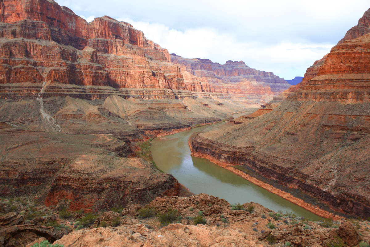
Desert View Drive: The Grand Canyon's greatest hits album
The 25-mile Desert View Drive offers nine major viewpoints along the Grand Canyon's South Rim between Grand Canyon Village and the Desert View Watchtower. Each viewpoint reveals different perspectives of two-billion-year-old geological history, which is a nice way of saying "really, really old rocks."
This section climbs from 7,096 feet at Pipe Creek Vista to 7,461 feet at Navajo Point, the South Rim's highest viewpoint. Despite offering superior Colorado River views, it receives fewer crowds than the village area, probably because most tourists don't realize there's more to the Grand Canyon than the visitor center gift shop.
Must-see stops on Desert View Drive:
- Grandview Point (mile 251) with historic mining trail
- Tusayan Pueblo (mile 262) and museum
- Desert View Watchtower for 360-degree views
- Multiple sunrise photography spots
The 70-foot Desert View Watchtower, designed by architect Mary Colter in 1932, features authentic Native American murals and remains one of the few historic buildings where you can climb stairs older than your grandparents. The structure provides 360-degree views that'll make you understand why the Grand Canyon attracts 4.7 million visitors annually despite the $35 per vehicle entrance fee.
Hidden gems that locals gatekeep (until now)
Salt River Canyon: Arizona's "other" Grand Canyon
US Route 60 through Salt River Canyon delivers what Arizona Highways calls the state's "mini Grand Canyon," yet surprisingly few Arizonans have driven this spectacular 83.5-mile route from Globe to Show Low. Unlike its famous cousin, drivers actually reach the canyon floor at just 2,500 feet elevation, where 1934 pedestrian and 1996 vehicle bridges span the Salt River.
The highway descends 2,000 feet through dramatic switchbacks that'll have you questioning your brake pad choices. The route passes through the San Carlos Apache Reservation, where 3,000-year-old petroglyphs mark Hieroglyphic Point near the rest area. These ancient artists apparently had the same instinct we do: "This view needs documentation."
One of the canyon's oddest features is a distinctive single palm tree standing after the bridge crossing. Nobody knows exactly how it got there, but it's become an unexpected landmark in this otherwise pine and desert landscape. It's like finding a penguin in the Sahara, except real and slightly less confusing.
Apache Falls, accessible via primitive road from the canyon bottom, remains a closely guarded secret among locals. Given that Arizona had 59 flash flood warnings statewide in 2024, checking weather conditions before exploring side roads isn't just smart… it's survival.
Coronado Trail: 460 curves of "are we there yet?"
US Route 191, formerly the infamous Route 666 (rebranded for obvious reasons), follows Spanish explorer Francisco Vasquez de Coronado's 1540 path through 460-plus curves between Springerville and Clifton. This 120-mile odyssey climbs from 3,465 feet to 9,300 feet, passing through five distinct climate zones.
Let me put this in perspective: that's more curves than a baseball pitcher's entire repertoire, compressed into a road that sometimes requires 10 mph speeds. It's one of the nation's least-traveled federal highways, probably because most people give up somewhere around curve 200.
Hannagan Meadow Lodge, built in 1926 at 9,000 feet elevation, provides the only accommodation along the entire route. It's a rustic mountain retreat where "rustic" is code for "hope you didn't need WiFi" and "retreat" means "because you can't go anywhere else."
Blue Vista Point at 9,184 feet offers expansive views across the Blue Range Primitive Area, one of the most remote regions in the American Southwest where reintroduced Mexican gray wolves roam. Yes, actual wolves. In Arizona. The desert state that can't make up its mind about what ecosystem it wants to be.
Coronado Trail survival tips:
- Fill up before starting (120 miles between gas stations)
- Pack snacks for 4-5 hour journey
- Download offline maps (no cell service)
- Check weather (snow possible October through April)
- Bring dramamine for sensitive passengers
Sky Island Scenic Byway: From cactus to snow in 27 miles
The Catalina Highway ascending Mount Lemmon achieves a 6,000-foot elevation gain in just 27 miles, transitioning from saguaro-studded Sonoran Desert to Canadian-zone forests. Despite attracting over one million annual visitors, this route remains lesser-known outside Southern Arizona.
The drive provides 30-degree temperature differences from Tucson's valley floor, which means you can literally experience winter and summer in the same afternoon. It's like having seasonal affective disorder, but in reverse and on purpose.
Windy Point Vista at 6,400 feet showcases wind-sculpted rock formations that attract world-class rock climbers to over 2,500 established routes. It's called Windy Point for a reason, so maybe leave the toupee at home.
Rose Canyon Lake at 7,200 feet supports trout fishing in an unexpected mountain setting, while Summerhaven village at 8,000 feet features restaurants and shops rebuilt after devastating 2003 wildfires. The Mount Lemmon SkyCenter operates a 32-inch telescope for public astronomy programs, taking advantage of some of the darkest skies remaining in the Southwest.
Planning your scenic drive adventure (without the disasters)
Success on Arizona's scenic drives requires more preparation than just filling your gas tank and hoping for the best. The optimal months for most routes are March through May and September through November, when temperatures won't melt your steering wheel and monsoons aren't trying to wash you into a canyon.
Essential planning checklist:
- Check az511.com for real-time road conditions
- Start with full gas tank always
- Pack one gallon water per person
- Download offline maps before departing
- Bring paper maps as backup
- Check vehicle fluids and brakes
- Carry emergency supplies year-round
- Verify current permit requirements
Summer monsoons between July and September create dramatic photography but equally dramatic flash flood conditions. These storms can transform a dry wash into a raging river faster than you can say "maybe we should have checked the weather." Winter snow can close mountain passes, particularly affecting the Coronado Trail and higher elevations of Oak Creek Canyon.
Early morning departures beat both crowds and heat. Parking at popular spots like Oak Creek Canyon's swimming holes fills by 10 AM on weekends, which means either arriving at dawn or perfecting your parallel parking skills in impossible spaces.
Vehicle requirements vary by route. Standard vehicles work fine for most paved routes, but high-clearance vehicles become necessary for the Apache Trail's unpaved section and certain Forest Service roads. Four-wheel drive isn't mandatory but provides peace of mind when weather turns unexpected.
Don't forget about permits and fees. Red Rock Passes cost $5 daily or $20 annually for Sedona-area trailheads. Grand Canyon charges $35 per vehicle for seven-day access. Some tribal lands require additional permits, because nothing says "scenic drive" like bureaucracy.
Professional travel photographer Lisa Michele Burns puts it best: "Arizona might seem harmless, but it's tough. Bring water, don't get too close to cliff edges, and watch for ice on the roads." This is excellent advice from someone who's probably learned these lessons the hard way.
Your adventure awaits
Arizona's scenic drives deliver far more than pretty views and Instagram opportunities. They're journeys through deep time, diverse ecosystems, and dramatic topography that exists nowhere else in America. Whether you're white-knuckling it down the Apache Trail, sliding down natural water chutes in Oak Creek Canyon, or wondering how a palm tree ended up in Salt River Canyon, these roads transform simple transportation into unforgettable adventures.
The famous routes deserve their reputations, offering accessible adventures that explain why Arizona attracts over 40 million annual visitors. But the hidden gems arguably surpass their famous cousins, rewarding adventurous drivers with equally spectacular scenery minus the tour buses and trinket shops.
The key isn't rushing between viewpoints like you're collecting Pokemon. It's about embracing the journey itself, even when that journey includes 460 curves, missing guardrails, or elevation changes that make your ears pop every five minutes. Each route tells a different story written across landscapes that challenge comprehension while rewarding those who take time to truly experience them.
So fill up your tank, pack more water than you think you need, and prepare for roads that redefine the term "scenic drive." Just remember: in Arizona, the journey isn't just better than the destination… sometimes it literally is the destination.