
Let me guess… you thought Idaho was just potatoes and Napoleon Dynamite references? Well, buckle up buttercup, because this state's 31 scenic byways are about to blow your mind harder than finding out your GPS actually works in the wilderness.
Why Idaho's roads deserve your rubber
Idaho somehow convinced the bigwigs to give it two All-American Road designations, which is basically the Oscar of scenic driving. The International Selkirk Loop even scored the title of "West's Best Scenic Drive" from Sunset Magazine, probably because the judges got distracted by all the moose and forgot they were supposed to be impartial.
These routes pull in about $37.4 million annually for local communities, making tourism Idaho's third-largest industry after, well, potatoes and asking tourists if they've tried the potatoes. Since 1977, the Idaho Transportation Department has been curating these routes like a fine wine collection, except instead of getting you drunk, they get you high… on elevation changes from 740 feet to 12,662 feet.
The variety here is absolutely bonkers. You can drive from ancient 2,000-year-old cedar groves to lunar-like lava fields in the same day. Routes range from the bite-sized 28-mile Mesa Falls jaunt to the marathon 280-mile International Selkirk Loop that crosses into Canada (passport required, maple syrup appreciation optional).
The magnificent nine: Idaho's greatest hits
Before we dive into each route, know that picking favorites from 31 scenic byways is like choosing a favorite child… some parents do it, but they shouldn't admit it publicly. These nine routes showcase everything from celebrity hideaways to atomic history, from waterfalls that haven't been Instagram-filtered to death, to fault lines that literally moved mountains.
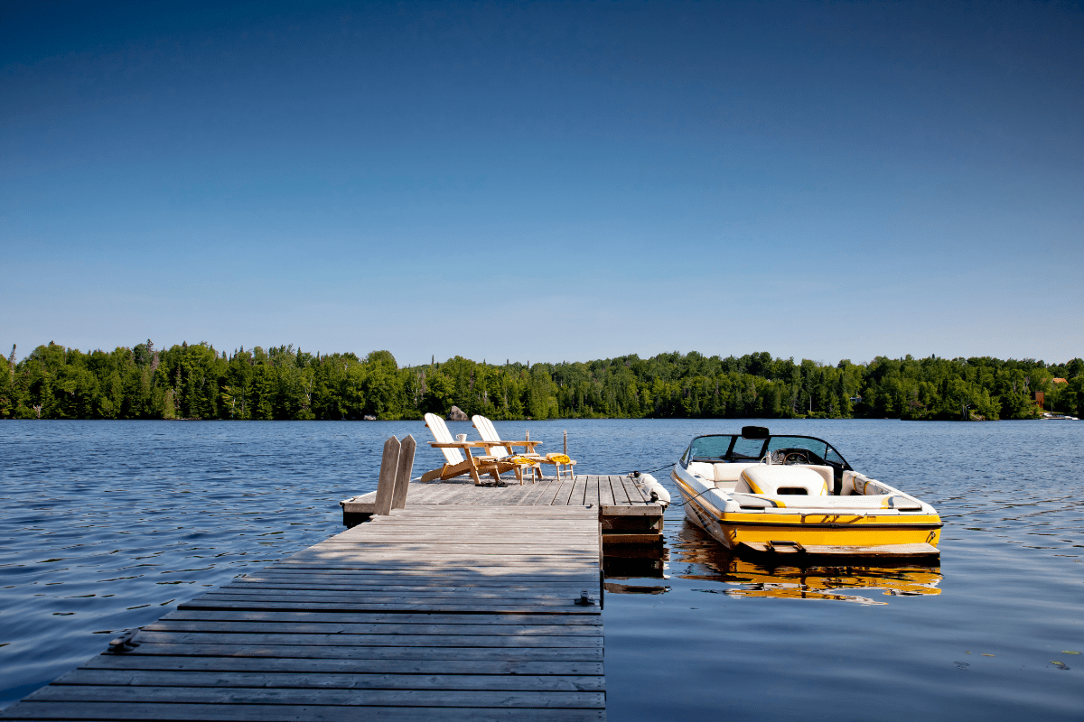
Lake Coeur d'Alene: Where the ospreys outnumber the tourists
Highway 97 traces 35.8 miles along Lake Coeur d'Alene's eastern shore, hosting the largest osprey population in the Western United States. These fish-eating raptors apparently got the memo about Idaho's hidden gems before humans did.
The 1.5-hour drive starts at 2,200 feet near Wolf Lodge Bay and gently climbs to 2,800 feet, because even Idaho's "flat" routes can't help showing off a little. December through January transforms the route into bald eagle central, with the majestic birds congregating between Wolf Lodge Bay and Beauty Bay like retirees at an early bird special.
Key stops worth your brake pads:
- Mineral Ridge Trail (mile 8): 3.3-mile loop
- Anderson Lake (mile 25): Wildlife management area
- Harrison: Historic paddlewheel port with actual services
The best part? Harrison has gas, food, and lodging, because nothing ruins a scenic drive faster than running out of fuel while an elk judges you from the roadside.
Northwest Passage: Lewis and Clark's original road trip
This 202-mile behemoth follows US Highway 12 from Lewiston to Montana, tracing Lewis and Clark's exact route. Starting at just 740 feet where the Snake and Clearwater Rivers meet, the road climbs to 5,233 feet at Lolo Pass, because apparently Lewis and Clark didn't believe in easy mode.
The Nez Perce National Historical Park Visitor Center at Spalding (mile 12) provides context for understanding the Nimíipuu people's homeland. Further along, Dworshak Dam stands 717 feet tall, making it the third-tallest dam in the US and definitely taller than your apartment building.
The route passes through the Selway-Bitterroot Wilderness before reaching Devoto Cedar Grove at mile 160, where trees over 2,000 years old make you feel pretty insignificant about your morning productivity goals. Winter drivers beware: black ice loves hiding in shadowy canyons like a ninja with a vendetta against your insurance premiums.
Sawtooth Scenic Byway: Hemingway's backyard playground
The 115-mile journey from Shoshone to Stanley on Highway 75 climbs nearly 5,000 feet, passing through Sun Valley where Ernest Hemingway spent his winters presumably complaining about writer's block and enjoying the skiing.
Sun Valley and Ketchum (mile 50) offer a glimpse into Papa Hemingway's world, including his final resting place in Ketchum Cemetery. He wrote portions of "For Whom the Bell Tolls" here, probably while staring at mountains and feeling deeply philosophical about fish or something.
The route's crown jewel is Galena Summit at 8,701 feet, where a viewpoint reveals the entire Sawtooth Valley with 57 peaks over 10,000 feet. This area is part of America's first gold-tier International Dark Sky Reserve, encompassing 1,416 square miles of pristine night viewing that'll make your city-dwelling friends weep with envy.
Wildlife watching north of Galena Pass includes:
- Pronghorn antelope
- Mountain goats doing their cliff thing
- Sandhill cranes
- Elk pretending they own the road
Near Shoshone, volcanic ice caves harbor living glaciers, because Idaho likes its geology like its politics: surprisingly complex and occasionally frozen.
Ponderosa Pine: Boise's backyard escape route
Highway 21 stretches 101.4 miles from I-84 southeast of Boise to Stanley, climbing from 3,000 feet through forests that smell better than any car air freshener ever could. Banner Creek Summit tops out at 7,056 feet, giving you roughly 4,000 feet of elevation gain to make your ears pop.
Idaho City at mile 38 preserves its 1860s gold rush swagger with opportunities to pan for gold and pretend you would have survived the frontier days (spoiler: you wouldn't have). The route's most thrilling section involves steep switchbacks dropping 2,240 feet from Beaver Creek Summit to Lowman, where your brake pads earn their keep.
The 1989 wildfire regeneration area serves as nature's reminder that sometimes you need to burn it all down and start fresh… metaphorically speaking, please don't actually start any fires. Stanley Lake turnoff at mile 97 leads to one of Idaho's most photographed spots, where McGown Peak reflects in alpine waters like nature's own Instagram filter.
Winter closures happen frequently due to avalanche danger, because mountains don't care about your vacation schedule. The 35-mph winding sections around Beaver Creek Summit will test your passenger's trust in your driving skills.
Peaks to Craters: From Idaho's ceiling to its basement
This 140-mile odyssey requires a full day unless you're the type who rushes through museums to say you've been there. The route connects Idaho's highest mountain with its youngest volcanic landscapes, starting near Challis at 5,004 feet.
Willow Creek Summit at 7,161 feet offers views of Mount Borah, Idaho's highest peak at 12,662 feet. The Lost River Fault Scarp at mile 40 preserves evidence of the 1983 earthquake that literally moved mountains… dropping the valley floor six feet while raising Mount Borah another foot, because geology doesn't do anything halfway.
Must-see geological drama:
- Mackay Reservoir: Rainbow trout and mountain views
- Nine of Idaho's twelve 12,000-foot peaks
- 20-mile-long earthquake scar still visible
- Craters of the Moon: 750,000 acres of lava
Arco holds the distinction of being the first city lit entirely by atomic energy in 1955, which is either really cool or mildly terrifying depending on your perspective. The journey ends at Craters of the Moon, where eight major eruptions between 15,000 and 2,000 years ago created a landscape that NASA used for Apollo astronaut training.
Mesa Falls: The waterfalls that time forgot
Highway 47's compact 28.7 miles near Ashton showcase the last undisturbed major waterfalls in the American West. Open May 15 through October 1, because even waterfalls need their beauty sleep apparently.
Upper Mesa Falls plunges 114 feet while Lower Mesa Falls drops a modest 65 feet, both tumbling over volcanic rock from prehistoric super-eruptions that make modern volcanoes look like firecrackers. Warm River Bridge at mile 9 provides exceptional wildlife viewing for river otters who've mastered the art of looking adorable while being absolutely savage fish hunters.
The route ends at Harriman State Park, an 11,000-acre wildlife refuge on the historic Railroad Ranch. From 1902 to 1977, the Guggenheim and Harriman families ran this spread, probably hosting parties that would make Gatsby jealous. Today, elk, moose, trumpeter swans, and sandhill cranes call it home, living better than most of us.
Teton Scenic Byway: The mountains' good side
This 69-mile route from Swan Valley to Ashton provides Idaho's best Teton views via Highways 31, 33, 32, and 47. Pine Creek Pass at 6,754 feet features a 6% grade that'll make your transmission question your life choices.
Starting in Swan Valley's fly-fishing paradise around 5,000 feet, the route gains 3,251 feet total, because flat is boring and Idaho knows it. The panoramic views from Pine Creek Pass showcase Grand Teton at 13,770 feet, Middle Teton at 12,804 feet, and South Teton at 12,514 feet, best photographed driving eastward to catch morning light on the peaks.
Quirky stops that'll make you smile:
- Victor (mile 35): Victor Emporium ice cream
- Driggs (mile 45): Idaho's oldest ice cream shop
- Annual Mountain Man Rendezvous in Driggs
- Frequent wildlife crossings near Pine Creek
The route stays open year-round, though winter creates ice rink conditions on that 6% grade. Deer, elk, and moose cross frequently, especially during dawn and dusk when they're commuting to wherever woodland creatures commute to.
Thousand Springs: Where water does magic tricks
Highway 30's 67-mile stretch between Bliss and Twin Falls reveals where the Snake River Plain Aquifer emerges through canyon walls after traveling 2,308 miles underground. It's like nature's longest magic trick, with the big reveal happening all along the canyon.
Dropping from 3,600 feet at the rim to 3,000 feet at river level, the road takes you past Blue Heart Springs, a hidden turquoise cove accessible only by boat or kayak, because the best things in life require effort. Thousand Springs State Park encompasses six units where waterfalls pour from basalt walls like nature's infinity pools.
Hagerman hosts fossil beds containing ancient horse remains and produces 70% of America's commercial trout, making it technically more important to your sushi habit than you realized. The route culminates at Shoshone Falls near Twin Falls, plunging 212 feet… that's 36 feet higher than Niagara, for those keeping score.
The Perrine Bridge stretches 1,500 feet across the canyon at 486 feet above the river, serving as one of the few legal BASE jumping sites in the US. Because apparently, driving next to a massive canyon isn't thrilling enough for some people.
International Selkirk Loop: The overachiever route
North America's only multinational scenic route covers 280 miles through Idaho, Washington, and British Columbia. Idaho's 110-mile portion follows Highways 2 and 95, maintaining a gentle 2,100-foot elevation because it's saving the drama for the other states.
The route hugs the Pend Oreille River's northern shore for 28.5 miles through Dover and Priest River to Sandpoint. Lake Pend Oreille, Idaho's largest natural lake at 43 miles long and up to 1,150 feet deep, probably has its own weather system and definitely has its own submarine testing facility (seriously, the Navy tests subs here).
From Sandpoint, Highway 95 continues north through Bonners Ferry to the Canadian border, passing the Kootenai National Wildlife Refuge where 2,774 acres host moose, deer, elk, and eagles living their best lives. The Selkirk Mountains rise dramatically to the east, with Scotchman Peak's mountain goats judging your hiking abilities from 7,009 feet.
Planning your Idaho road trip adventure
Now that you're thoroughly convinced Idaho is more than spuds and Napoleon Dynamite, let's talk logistics. Because nothing ruins a scenic drive faster than poor planning, except maybe discovering your "scenic viewpoint" is actually someone's driveway.
When to go (and when to stay home)
May through October offers the best conditions for most routes, when mountain passes are clear and wildlife is active. Lake Coeur d'Alene and Thousand Springs work year-round for those who can't wait for summer. Winter transforms mountain routes into icy slip-n-slides, with the Ponderosa Pine route particularly prone to avalanche-related closures.
Check road conditions before heading out, especially for mountain passes where weather changes faster than fashion trends. Black ice lurks in shadowy canyon sections like that friend who always suggests "one more drink" when you clearly should go home.
Essential survival tips
Practical advice from someone who's learned the hard way:
- Keep your tank above half-full always
- Pack extra water for desert sections
- Download offline maps before leaving
- Bring snacks (hangry scenic driving isn't scenic)
- Tell someone your route plans
- Carry emergency supplies year-round
- Camera battery backups are essential
- Sunglasses aren't optional at elevation
Services can be sparse between towns, particularly on the Peaks to Craters route. Carey, Arco, Mackay, and Challis have fuel, but they're spread out like toppings on a gas station pizza.
Connecting the dots
Smart route connections can turn a day trip into an epic adventure. The Sawtooth Scenic Byway connects seamlessly with Ponderosa Pine at Stanley, creating a Boise-to-Boise loop that'll leave you pleasantly exhausted. Peaks to Craters can extend north to join the Salmon River Scenic Byway at Challis for those who measure vacation success by miles driven.
Multiple byways link naturally for multi-day expeditions, though your passenger might start questioning your definition of "vacation" somewhere around day three of continuous mountain switchbacks.
Final thoughts from the road
Idaho's scenic byways transform driving from point-A-to-point-B transportation into something approaching spiritual experience… or at least Instagram-worthy content. These 31 routes showcase everything from ancient forests to atomic age history, from pristine lakes to volcanic wastelands, all connected by ribbons of asphalt that somehow make the journey more important than the destination.
Whether you're chasing waterfalls on Mesa Falls, contemplating existence at Hemingway's grave, or wondering why anyone thought settling in a place called "Craters of the Moon" was a good idea, Idaho's scenic drives deliver stories worth telling. Just remember to actually look up from your camera occasionally… the views are even better without a screen in the way.